


GPS
Most everyone has heard of GPS (Global Positioning System) which relies on a series of satellites transmitting electronic ‘messages’ to GPS Receivers on the ground. These messages include precise time information (each satellite carries an atomic clock) and details of the satellite orbit. This information is used by the GPS Receiver to ‘triangulate’ its position and height, as well as receiving an accurate time source.
There are currently 31 operational GPS satellites in orbit, and if more than three are ‘in view’ at any one moment in time then a fairly accurate ‘fix’ of position (latitude and longitude) may be obtained; however best results are obtained from more than six satellites being in-view. From most parts of the world, given a good vantage point and weather conditions, between eight and twelve satellites will be simultaneously in-view.
GPS is an American System which was designed for both civil and military use. Initially the satellites transmitted a ‘wobble-factor’ that caused civilian GPS Receivers to be accurate to around 100 m. This “Selective Availability” system ceased in 2000, allowing civilian GPS receivers to now be accurate to around 20 m, although many manufacturers are claiming far better accuracy from modern devices.
GPS is now commonly used as a navigation aid, for surveying and map producing, tracking and surveillance, and hobbies such as Geocaching. The precise time reference can be used for scientific purposes such as seismic studies and as a time source for Mobile Phone Networks.
GPS Receivers. There are many different types of GPS receiver, but in the ‘domestic’ world (as opposed to military or scientific) there are seven main consumer variants:
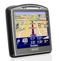
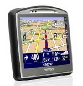
Portable Vehicle Navigation. These are small portable receivers that can be fitted into a vehicle mount on the windscreen or dashboard. They can be self-powered from an internal battery, or powered from the vehicle supply. Guidance is by visual indication on the screen, and most systems have voice guidance. They have their own internal aerial, thus sensitivity can be poor-to-medium depending on where they are fitted inside the vehicle. The Map Data are generally confined to main vehicle routes, roads and tracks are updated usually from a connection to a home computer. ‘Waypoints’ and ‘Points of Interest’ (including Speed Camera locations!) can usually be uploaded into these units. Updates can often be found as free Internet downloads.
Fixed Vehicle Navigation. Similar in operation to the Portable devices, these are factory-fitted, usually as a ‘new purchase’ option. They use a vehicle mounted aerial thus sensitivity is very high. They are more convenient as there is no special mount or trailing wires to worry about, but as the Map Data are updated via a vehicle fitted CD Drive there are less options of update available, and updates are generally expensive.
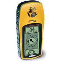
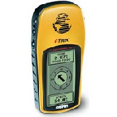
Handheld GPS Receivers. These are small battery powered devices with screens of around 2.5 to 4 cm size, either in grayscale or colour. Colour devices have a much poorer battery life, between 6 and 10 hours; Grayscale devices can run for as long as 20 hours. The inexpensive ‘mono’ devices (£70 - £120) show basic Tracks, Routes and Waypoints only, and most have a ‘Compass Waypoint Direction’ mode that ‘points’ to the next Waypoint or Geocache. The colour devices (£170 - over £500) use ‘topographical’ Maps, with Rights of Way, tracks ,countryside details such as woods and streams, and contours. This sets them apart from the traditional vehicle navigation devices. Many can be supplied with Ordnance Survey Mapping Data, making them extremely useful for serious walking and hiking. Map Data are downloaded from a home computer, which can be a mix of Routes, Tracks and Waypoints.
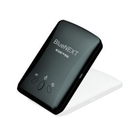
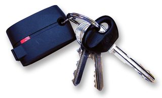
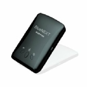
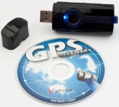
GPS Receiver - Data Output. These are small self-powered Receivers with no visual display - see image left. Data from the Receiver are ‘outputted’ via Bluetooth (see below) or Serial Port. These Data are usually in a standard format, normally NMEA 0812 which can be ‘understood’ by most mapping and GPS software. Modern GPS Bluetooth Receivers are capable of 51-Channel reception and can operate for well over 24 hours. Sensitivity is high and they operate well in the top or side pocket of a rucksack.
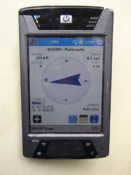
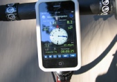
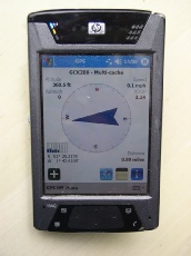
Portable Digital Assistants (PDAs). Most PDAs running Windows Mobile 2003, 6 or 7 have on-board ‘Bluetooth’ that can connect to external GPS Receivers, as mentioned above - see image left. A range of software is available for standard vehicle navigation, topographical mapping, as well as dedicated Geocaching ‘compass navigation’ (see image left). Some software is even free! These can be an excellent solution for many people, as they operate as a standard Portable computer, with Email/Contact/File synchronisation with a home computer, can playback MP3 and Video files, and have a traditional Word Processor and Web Browser if Wireless is fitted. See our Supplies Page for details of purchasing a complete Handheld PDA/GPS Package.
N.B. More recent Windows Mobile Devices are fitted with on-board GPS, but please be warned, these are usually ‘Assisted’ GPS (A-GPS) which uses a Cellular Telephone connection for much of the navigation system - this can prove expensive.
Mobile Telephones. A few Mobiles phones are available with on-board GPS. However we have found them to be insensitive with poor quality mapping software, and are most always ‘Assisted-GPS’ (where the primary loacational ‘fix’ is made via a Phone data connection). They are OK for general navigation around a town, but are no contender when it comes to walking, hiking and Geocaching
GPS Receiver - Data Logging. Another Receiver with no visual display. These are a small surveillance product with a USB Connection, and often with a ‘Record Location Point’ Button. Simply pop the receiver into your top pocket or top of your rucksack, and on your return download your ‘track, into Mapping software to see where you have been and how far you have walked or travelled. Take photographs with a Digital Camera with accurate Clock, and integrate these with Google Maps TM.
Great for tracking ‘Fido’ to see where he has been when out roaming at night-time!
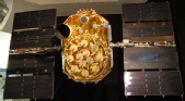
A GPS Satellite
prior to launch
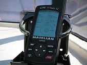
A Magellan
GPS Receiver
GEOCACHING
Geocaching is an interesting new activity in which ‘Geocachers’ use GPS to ‘hide’ and ‘seek’ containers called geocaches or just ‘caches’. These are usually waterproof plastic containers ranging from ammunition box size down to to dog identity collar size (‘micro cache’). Most all but the smallest containers with have some form of logboook; the larger containers will also contain swappable items. There are nearly 1 million Caches hidden across the world, with around 100,000 in the United Kingdom.
There are many different types of Geocache:
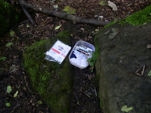
Traditional. Usually Ammo-Box or medium-sized Tupperware box, containing a log book of some sort , swappable items, and traceable items. The Geocache is located at a fixed set of coordinates.
Multi-Cache. This consists of multiple discoveries of one or more intermediate points containing the coordinates for the next stage; the final stage contains the log book and trade items.
Offset. This cache is similar to the multi-cache except that the initial coordinates are for a location containing information that encodes the final cache coordinates. An example would be to direct the finder to a plaque where the digits of a date on the plaque correspond to coordinates of the final cache.
Mystery/Puzzle. This cache requires one to discover information or solve a puzzle to find the cache. Some mystery caches provide a false set of coordinates with a puzzle that must be solved to determine the final cache location. In other cases, the given location is accurate, but the name of the location or other features are themselves a puzzle leading to the final cache. Alternatively, additional information is necessary to complete the find, such as a padlock combination to access the cache.
Letterbox Hybrid. Letterboxes have been around for 150 years or so; originally being sited on what are now the National Parks. A letterbox hybrid cache is a combination of a Geocache and a letterbox in the same container. The Letterbox has a rubber stamp and a logbook instead of tradable items. People seeking letterboxes carry their own stamp with which to stamp the letterbox's log book, and use the Letterbox stamp to stamp their personal log book. A hybrid cache contains the stamp/logbook as well as the basic Cache logbook, and may well have trade items as well.
Virtual: Caches of this nature are simply the coordinates for a location that does not contain a cache at all. Instead, the location will have some form of ‘feature’. Validation for finding a virtual cache generally requires you to email the cache hider with information such as a date or a name on a plaque, or to post a picture of yourself at the site with GPS receiver in hand.
Cache-In Trash-Out (CITO) Events. This variation on event caching is a coordinated activity of rubbish collection and other work to improve the environment.
Getting Started with Geocaching
Want to try Geocaching but don’t know how to start or whether to purchase a GPS Handheld? The why not enlist on our Geocaching Starter Course?

Click here to see this PDA running Geocache software

| Avebury |
| Kennet Valley |
| Martinsell |
| Marlborough |
| Savernake |
| Villages |
| West Woods |
| Custom Walks |
| Self-Guided Walks |
| Map & Compass |
| Ley Line Dowsing |
| Ancient Trees |
| Walking for Beginners |
| Beginners Backpacking |
| Geocaching |
| Corporate |
| Activities |
| Activities |
| Corporate |